TLDR
• Core Points: A global Minecraft project aims to recreate the Earth block by block at true scale via Build The Earth, with New York City as a flagship 1:1 replica created by thousands of volunteers under the leadership of PippenFTS.
• Main Content: The endeavor, coordinated by Build The Earth, mobilizes regional teams to model real-world locations in Minecraft, emphasizing accuracy, collaboration, and scalable participation.
• Key Insights: Community-driven digital archaeology is reshaping collaborative large-scale builds, highlighting challenges of data accuracy, project governance, and long-term maintenance.
• Considerations: Sustained funding, on-site data verification, intellectual property considerations, and ensuring accessibility for new builders are ongoing needs.
• Recommended Actions: Support ongoing volunteer recruitment, refine data sources and mapping tools, establish transparent governance and QA processes, and develop public-facing tutorials to lower entry barriers.
Content Overview
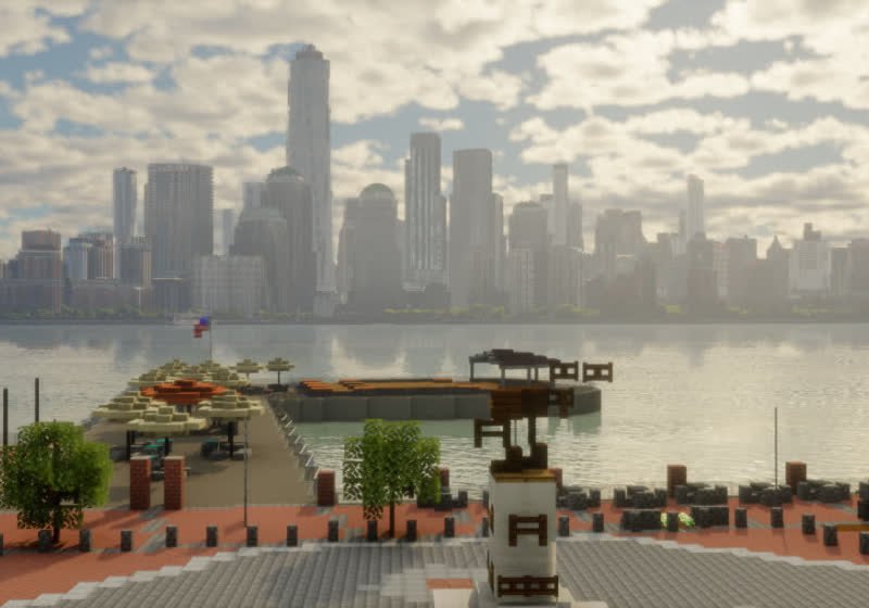
Build The Earth (BTE) is a global initiative that invites Minecraft players to reconstruct Earth in the game at true scale, block by block. Spearheaded by YouTube creator PippenFTS, the project envisions a living, shareable replica of the planet, where every street, building, and terrain feature exists in the digital world with pixel-perfect fidelity. The community aspect is central: thousands of volunteers join regional teams to model cities, landscapes, and landmarks within Minecraft’s sandbox environment. The New York City area is one of the most prominent and active hubs within the BTE network, reflecting the project’s ambition to tackle highly complex, densely built urban environments.
The concept of creating a 1:1 replica in Minecraft is inherently ambitious. Minecraft’s world uses a block-based coordinate system with a limited representation of real-world geometry, but modern tools, satellite imagery, and collaborative workflows have enabled large-scale projects to push toward high fidelity. The New York City effort showcases the blend of art, engineering, and open collaboration that underpins BTE. Teams may segment the city into districts or boroughs, assign responsibilities, and coordinate via shared repositories, design guidelines, and version control. The scale of New York—with its dense skyline, intricate street grid, parks, and transit nodes—presents a proving ground for the community’s ability to manage complexity, maintain consistency, and verify accuracy.
The project’s governance model relies on volunteer leadership, regional coordinators, and a collective ethos of open collaboration. Quality assurance mechanisms, documentation, and clear contribution guidelines help keep nearly innumerable pieces of data aligned with real-world geography. As with many large, volunteer-driven efforts, the process involves iterative builds, community feedback loops, and ongoing updates as new data becomes available or as the project’s scope shifts.
This article synthesizes what is publicly known about Build The Earth’s New York City replica, its organizational structure, technical approaches, and the broader implications of such mass-participation, cross-border digital construction projects. It also addresses potential challenges and opportunities that arise when coordinating thousands of contributors around a shared digital geospatial objective.
In-Depth Analysis
Build The Earth represents a novel experiment in collaborative digital mapping, training, and preservation through video-game tooling. At its core, the initiative asks: can an entire planet be faithfully recreated inside a Minecraft world, with a commitment to scale accuracy and openness? The New York City segment embodies this dream in a particularly demanding urban context, where towers rise over streets that themselves are densely configured, and where nuanced details—from transit hubs to park boundaries—carry cultural and practical significance.
Coordination among thousands of builders requires an organized framework. Regional teams—often led by experienced volunteers—divide the workload into manageable chunks, such as boroughs, neighborhoods, or significant landmarks. Clear naming conventions, consistent building standards, and shared texture packs or resource packs help maintain visual and structural coherence across the project. This is essential given how many independent contributors can affect adjacent areas; without standards, the result could appear disjointed or inconsistent.
Data sources and accuracy play a central role in the project’s credibility. Builders commonly rely on satellite imagery, public records, GIS data, and street-level photography when available. The objective is to translate three-dimensional real-world forms into the block-based constraints of Minecraft while preserving proportions, massing, and recognizable silhouettes. In practice, this involves interpreting curbs, street widths, and building footprints, then deciding how to represent materials and facades within the game’s artistic constraints. The process often requires compromises—indirect representations of certain details or stylistic shorthand—to maintain an overall sense of authenticity without sacrificing playability or performance.
Technical challenges are nontrivial. Rendering large urban districts in Minecraft requires managing a heavy load of blocks, entities, and lighting, which can impact server performance and client framerates. To address this, builders may employ zoning strategies, level-of-detail adjustments for distant structures, and optimization techniques such as chunk loading controls and multi-server architecture. The New York City area, with its dense mid- to high-rise towers and complex transit corridors, tests the limits of what can be achieved in real time on community hardware and shared servers. As the project progresses, performance tuning becomes a moving target, often requiring updates to software plugins, resource packs, and server configurations.
Volunteer dynamics and governance shape the project’s long-term viability. A large-scale, open collaboration is sustained by a mix of enthusiasm, recognition, and practical incentives—such as opportunities to contribute to a widely viewed project, gain experience with digital cartography and large-scale worldbuilding, and connect with a global network of builders. Governance typically evolves to include documented contribution guidelines, licensing for shared assets, and transparent decision-making processes about scope changes or disputes. The leadership often emphasizes inclusivity, mentorship, and the importance of creating a welcoming environment for new builders who want to learn the craft of large-scale construction in Minecraft.
Quality control remains a persistent concern. Because the project relies on hundreds or thousands of individual builds, there is a need for consistent review processes. QA workflows might include percussion checks like verifying that a district’s street grid aligns with real-world datasets, cross-referencing notable landmarks against reference shots, and confirming that major transit nodes such as subway stations are placed accurately relative to surrounding infrastructure. Public documentation—such as build logs, change histories, and district maps—helps maintain accountability and allows community members to track progress and propose revisions.
Beyond the practical aspects, Build The Earth’s New York City replica has cultural and educational dimensions. It offers a way to explore urban form, historical growth patterns, and architectural diversity within an interactive medium. Students, educators, and hobbyists can study the city’s layout, massing, and typologies while engaging with a collaborative digital artifact that mirrors real-world geography. The project also raises questions about the balance between accuracy and interpretation in a creative medium; while the goal is faithful replication, the collaborative nature of the build inevitably introduces subjective decisions about how best to represent complex urban environments.
The initiative’s impact is not limited to the Minecraft community. It intersects with discussions about digital twins, urban planning, and the democratization of map-based knowledge. As more regions are mapped and added, the project can become a resource for people who want to visualize how a real city might look under different design interventions or at different scales. It also highlights the potential for citizen-led projects to contribute to large-scale digital representations of the world, complementing professional GIS and architectural workflows with the participatory energy and creativity of hobbyists.
Looking ahead, sustaining momentum will require addressing several key areas. First, ongoing data verification and quality assurance will be essential to preserve the project’s credibility. Second, expanding access for new builders—through tutorials, mentorship programs, and simplified onboarding—will help preserve growth trajectories and prevent burnout among veteran contributors. Third, funding and resource allocation, including server costs, asset creation, and potential licensing considerations, will influence the project’s ability to scale to additional regions or adapt to evolving game updates. Finally, fostering collaboration with professional communities—such as urban historians, architects, and GIS specialists—could enrich the geographic fidelity and educational value of the build.
The New York City replica is not just a technical feat; it is a social and collaborative experiment. It tests how a diverse, global community can converge on a shared vision and execute a project that would be impractical for any single organization to accomplish alone. The work embodies a particular spirit of open collaboration: a collective pursuit of demonstrating what is possible when thousands of volunteers bring their time, skills, and imagination to a common digital stage. As the project continues to grow, it will likely inspire similar efforts in other cities and regions, expanding the network of builders who see Minecraft as a platform for large-scale urban representation rather than a simple game world.
*圖片來源:Unsplash*
Perspectives and Impact
The Build The Earth approach to digital world-building embodies several broader trends in online collaboration and digital humanities. It leverages the appeal of Minecraft as a universal and accessible canvas, transforming it into a tool for education, urban exploration, and communal mapping. The New York City team’s work demonstrates how a highly recognizable real-world landscape can become a platform for collective learning and experimentation, inviting participants to engage with the city’s geography in new ways.
From a community perspective, the project fosters mentorship and skills development. New builders learn core competencies such as spatial reasoning, architectural vocabulary, and coordinate management. They also gain exposure to version control concepts, asset management, and the importance of documentation in collaborative environments. The project’s openness—where anyone can contribute given the right guidance—creates an inclusive path for people who might not have access to formal architecture or GIS education but want to participate in a meaningful digital project.
Conversations about accuracy and representation are central to the project’s discourse. Because the virtual replica exists for public use, there is an implicit expectation that the representation will be credible and respectful of real-world structures. The challenge lies in reconciling Minecraft’s stylized aesthetic with the precision demanded by a 1:1 replication. The New York City build illustrates this balance: recognizable silhouettes and street layouts align with real-world dimensions, while some details are stylized to fit the medium’s constraints. The result is a partially faithful, highly legible urban canvas that still serves as a community-driven interpretation rather than a perfect factual monument.
Educationally, BTE’s New York City build has potential as a resource for teaching geography, urban planning, architecture, and history. Students can examine how a city evolves, why certain neighborhoods have particular character, and how public spaces, transit infrastructure, and architectural typologies interact at scale. The project, however, also underscores limitations of digital replicas in conveying texture, materiality, and the experiential qualities of real streets. Complementary real-world maps, photos, and 3D scans provide a fuller understanding when integrated into classroom activities or public exhibits.
Future implications include the expansion of the BTE model to more cities and landscapes, potentially forming a global library of 1:1 replicas loved by hobbyists and educators alike. As the community grows, there will be opportunities to collaborate with universities, cultural institutions, and municipal planners who seek to visualize urban change. The project also raises important questions about data rights and licensing for textures and assets sourced from public and private domains. Clear guidelines will be essential to ensure that contributions respect copyright and community norms while enabling broad participation.
The New York City replica’s ongoing development will likely drive improvements in tools and workflows used by the broader Minecraft-building community. For example, better mapping pipelines, automated conversion of GIS data into Minecraft-ready formats, and enhanced synchronization across multiple teams can benefit not only BTE but any large-scale, geographically anchored project. These improvements can spill over into other voxel-based or procedurally generated projects that aim to model real places with high degrees of fidelity.
Ethical considerations also emerge in the course of such a project. Respect for the historical and cultural significance of certain sites, sensitivity to privatized spaces, and the potential for misrepresentation must be addressed through governance and contributor education. As with any large public project, transparency about methodologies, data sources, and decision-making processes helps build trust with audiences and participants alike.
In terms of long-term impact, the New York City replica could become a living archive of a city as it stood at a particular moment in time, capturing urban morphology and spatial relationships that might evolve or disappear in the real world. If maintained and updated, the project could document how neighborhoods change, how skyline aesthetics shift with new constructions, and how transportation networks adapt to growth. In that sense, it doubles as a digital ethnography of a city—an artifact that records the built environment and the aspirations of a community of builders.
Key Takeaways
Main Points:
– Build The Earth mobilizes thousands of volunteers to recreate Earth in Minecraft at true scale, with New York City serving as a flagship region.
– Coordination relies on regional teams, standardized guidelines, and shared data sources to maintain coherence across a sprawling, multi-author project.
– The project intertwines technical challenges, data accuracy, governance, and educational value, highlighting both opportunities and constraints of mass-participation digital mapping.
Areas of Concern:
– Maintaining data accuracy across a large, decentralized workforce.
– Ensuring long-term funding and resource sustainability for servers, assets, and tooling.
– Addressing licensing, privacy, and ethical considerations in publicly shared digital representations.
Summary and Recommendations
The New York City replica within Build The Earth exemplifies how large-scale, volunteer-driven projects can push the boundaries of collaborative digital construction. It blends gaming, mapping, urban studies, and education, inviting thousands to contribute to a shared vision of a city—rendered block by block at true scale. The project’s strength lies in its community-first approach, which rewards participation, mentorship, and ongoing contribution. However, the magnitude of the undertaking also reveals real challenges: preserving accuracy across diverse contributors, managing performance on complex builds, and ensuring that governance and QA keep pace with growth.
To sustain momentum and maximize the project’s positive impact, several steps are advisable:
– Strengthen onboarding and mentorship programs to lower barriers for new builders and reduce the learning curve.
– Invest in data pipelines that translate real-world geographic data into Minecraft-ready models with quality checks embedded at every stage.
– Formalize governance with transparent decision-making, licensing policies, and conflict-resolution procedures to maintain trust among participants.
– Expand educational outreach by developing guided activities and collaborations with schools, universities, and cultural institutions.
– Explore partnerships for funding and technical support, including cloud-based hosting to improve server performance and scalability.
– Enhance documentation and public communication to improve accessibility and keep the broader community informed of progress and standards.
If these measures are pursued, the New York City project could not only grow a robust, accurate digital replica but also establish best practices for large-scale, volunteer-driven digital cartography. It may inspire similar efforts in other cities and regions, amplifying the educational and cultural value of drivable, explorable digital urban landscapes while preserving the collaborative, open spirit that defines Build The Earth.
References
- Original: https://www.techspot.com/news/110964-thousands-join-forces-build-11-replica-new-york.html
- Additional context and related discussions on Build The Earth and large-scale Minecraft worldbuilding (to be added by the writer using publicly available sources such as project repositories, official blog posts, and community forums).

*圖片來源:Unsplash*