TLDR
• Core Points: MTG-S, the European Space Agency’s next-generation weather satellite, provides early imagery showing enhanced forecasting capabilities for Europe and Northern Africa.
• Main Content: Initial images reveal high-resolution atmospheric data intended to improve short- to mid-range weather prediction and support severe weather monitoring.
• Key Insights: The mission marks a significant step in geostationary observation, enabling rapid data relay, improved cloud and moisture analysis, and better decision-support for weather-dependent sectors.
• Considerations: Operational integration, data latency, and validation across regional weather centers will shape practical benefits.
• Recommended Actions: Stakeholders should prepare for broader data access, invest in assimilation systems, and align regional forecasting workflows with MTG-S outputs.
Content Overview
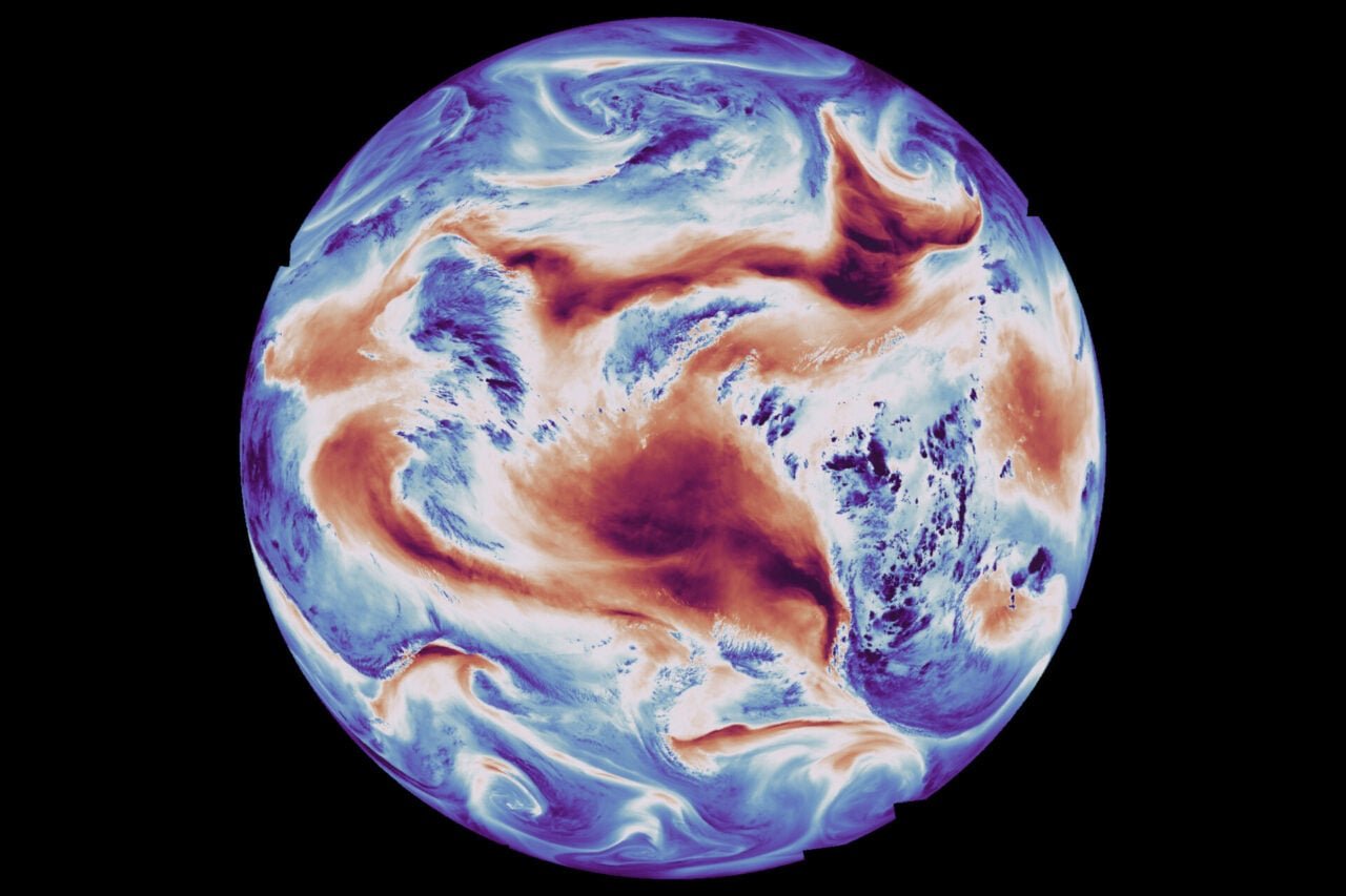
The European Space Agency (ESA) has unveiled the first images from MTG-S, the second phase of its Meteosat Third Generation (MTG) program. MTG-S stands as a companion to MTG-I (the Imager satellites) and is designed to deliver high-resolution atmospheric measurements from geostationary orbit. While MTG-I focuses on rapid, frequent imaging of the Earth’s disk, MTG-S emphasizes supplementary sensing modalities that enhance interpretation of atmospheric processes, precipitation, and extreme weather phenomena. The initial imagery provides a tangible glimpse into how MTG-S will contribute to more accurate forecasts across Europe and Northern Africa, regions frequently buffeted by storms, heat waves, and rapidly evolving weather systems.
The MTG program embodies Europe’s commitment to advancing numerical weather prediction and climate monitoring through continuous, high-fidelity data streams. By extending the temporal and spectral coverage of observations, MTG-S aims to reduce forecast uncertainty, shorten lead times for severe weather alerts, and improve the reliability of forecasts used by aviation, agriculture, energy, and emergency management sectors. The early data release signals not only technological progress but also the practical shift toward more proactive meteorology, where better observations translate into more informed decision-making.
In-Depth Analysis
MTG-S (Meteosat Third Generation – Second Satellite) is part of a coordinated strategy to modernize the European meteorological satellite fleet. While MTG-I satellites are optimized for rapid capture of visible and infrared imagery, MTG-S concentrates on additional sensing capabilities that complement those images. The combination is designed to deliver a more complete picture of atmospheric states, from wind fields and humidity profiles to cloud microphysics and precipitation intensity.
One of the core capabilities highlighted by the first MTG-S images relates to improved detection of atmospheric moisture, cloud structure, and convective activity. By refining how moisture content and cloud-top properties are retrieved, forecasters can better diagnose instability in the atmosphere, anticipate thunderstorm development, and quantify rainfall rates with greater confidence. These enhancements are critical for regions where weather evolves quickly and where accurate precipitation estimates influence flood warnings, agricultural planning, and water resource management.
The MTG-S instrument suite is designed to operate in synergy with MTG-I’s high-frequency imaging. While MTG-I satellites provide near-continuous snapshots, MTG-S adds complementary data streams that help interpret underlying physical processes. For example, advanced sounder-like channels can retrieve vertical moisture profiles and temperature distributions, enabling a more nuanced understanding of atmospheric layers than imagery alone can provide. This multi-instrument approach supports more robust data assimilation in numerical weather models, potentially reducing forecast errors over horizons of 24 to 72 hours and, in some cases, extending reliable lead times for specific weather events.
Beyond forecasting, the MTG-S data are expected to bolster near-real-time monitoring of severe weather and rapid onset hazards such as intense convective storms, strong winds, and high-impact precipitation. In practice, meteorological agencies will receive stream-aligned data products that can be integrated into warning systems, aviation routing, and disaster response frameworks. The tangible benefits hinge on several factors: the quality and consistency of data, the speed at which information can be ingested by forecasting centers, and the ability of national services to adapt their workflows to novel observation streams.
From a technical perspective, MTG-S embodies advances in satellite instrumentation, data handling, and communications. The satellite’s sensors are designed to deliver high spatial resolution with precise calibration, enabling cross-comparability with data from other satellites and ground-based instruments. In addition to scientific benefits, the broader impact of MTG-S includes improved climate monitoring capabilities, a better understanding of long-term atmospheric patterns, and enhanced capability to track changes in weather patterns over time.
Operational deployment involves a careful calibration and validation program. Early data are essential for confirming instrument performance, validating retrieval algorithms, and ensuring consistency with existing satellites in the series. Forecasters and researchers will work with MTG-S data to compare outputs against conventional observations, radar systems, and rain gauges to build confidence in the new products. The transition period will require close collaboration among European meteorological services, ESA, and international partners to harmonize data formats and ensure interoperability across different forecasting platforms.
While MTG-S represents a leap forward in observational capability, several practical considerations accompany such advancement. Data latency—the time between acquisition, processing, and dissemination—will influence how rapidly forecasters can act on new information. Moreover, the successful integration of MTG-S data into operational workflows depends on robust data dissemination networks, standardized product definitions, and the customization of assimilation systems within national meteorological centers. Ensuring continuity with the MTG-I constellation and future MTG-S successors also requires ongoing maintenance, calibration, and software updates.
The first images from MTG-S reveal a snapshot of a broader transformation in meteorology. They illustrate how an advanced satellite system can capture atmospheric chaos with clarity, supporting a more proactive approach to weather forecasting. The ongoing realization of MTG-S’s potential will involve a combination of continuous data production, algorithm refinement, and international cooperation in data sharing and application development.

*圖片來源:Unsplash*
Perspectives and Impact
The MTG program’s strategic value lies not only in immediate forecast improvements but also in long-term resilience against climate variability and extreme weather events. Europe and North Africa are regions that regularly contend with meteorological extremes, including heat waves, heavy rainfall, flash floods, and dust intrusions from arid zones. By delivering higher-quality observations, MTG-S contributes to a more robust early-warning ecosystem that can mitigate economic losses, protect lives, and support critical infrastructure.
From a scientific standpoint, MTG-S enables more detailed studies of atmospheric dynamics. Researchers can investigate microphysical properties of clouds, track moisture transport, and quantify convective tendencies with greater precision. This, in turn, informs climate research, helps validate atmospheric models, and improves our understanding of how small-scale processes aggregate to influence regional weather patterns. The satellite’s data also offer opportunities to cross-validate other remote-sensing assets, such as radar networks and ground-based sensors, fostering an integrated observational framework.
For the aviation sector, improved atmospheric profiling translates into more accurate wind and turbulence forecasts, potentially enhancing flight safety and efficiency. In agriculture and water management, better precipitation forecasts support planning and risk assessment, enabling farmers and water managers to optimize resource use and minimize losses. Emergency response agencies stand to benefit from earlier and more reliable warnings of severe weather, enabling more timely evacuations and protective actions.
International collaboration remains a cornerstone of MTG’s success. The European meteorological community has a long-standing history of data sharing and joint forecasting efforts, but the increasing volume and diversity of observations demand strengthened coordination. MTG-S will contribute to global datasets and improve interoperability with satellite systems operated by other space agencies. This collaborative posture also underpins the reproducibility of forecasts and the transfer of technology to other regions that could benefit from similar observational capabilities.
In the broader context of satellite meteorology, MTG-S exemplifies a trend toward multispectral, high-resolution, and near-real-time data streams. As technology evolves, future generations of weather satellites will likely emphasize even more rapid data dissemination, more sophisticated retrieval algorithms, and greater integration with in-situ observations. MTG-S sets a foundation for such advancements, demonstrating how end-user needs—ranging from weather prediction to disaster preparedness—drive the design and deployment of spaceborne observation systems.
Nevertheless, the path from first images to operational impact is not automatic. Realizing MTG-S’s full potential requires sustained investment in data processing infrastructure, rigorous quality control, and ongoing evaluation against independent measurements. Forecast improvements must be quantified across lead times, meteorological regimes, and geographic regions to build confidence among users. The eventual payoff will be measured in more accurate forecasts, quicker warnings, and a better understanding of the atmosphere’s chaotic nature as captured by an increasingly capable observing system.
Key Takeaways
Main Points:
– MTG-S represents a major enhancement to Europe’s Meteosat Third Generation program, complementing MTG-I with additional sensing capabilities.
– Early imagery demonstrates improved atmospheric profiling, with potential gains in forecast accuracy and lead times for severe weather events.
– Successful operational integration depends on data latency management, workflow adaptation, and international collaboration.
Areas of Concern:
– Data latency and processing bottlenecks could limit immediate forecaster benefits.
– Requires substantial investment in assimilation systems and training at national meteorological services.
– Interoperability with other satellite systems and continuity with MTG-I ongoing operations must be maintained.
Summary and Recommendations
The first MTG-S images provide a compelling preview of how Europe’s next-generation weather satellite will augment forecasting capabilities across Europe and Northern Africa. By delivering enhanced atmospheric profiling, MTG-S supports more accurate short- to medium-range forecasts, better detection of severe weather, and improved guidance for weather-sensitive sectors. The mission’s ultimate value will depend on the seamless integration of MTG-S data into forecasting centers, the speed of data delivery, and the reliability of retrieval algorithms that translate raw observations into actionable products.
To maximize impact, meteorological agencies and researchers should prioritize investments in data assimilation frameworks, product standardization, and staff training designed around MTG-S outputs. Strengthening international collaboration will also be critical to ensure uniform data quality and broad access to these advanced observations. In the long run, MTG-S is positioned to become an integral part of Europe’s weather and climate monitoring infrastructure, contributing not only to daily forecasts but also to climate research and resilience planning in a changing world.
References
- Original: https://gizmodo.com/next-generation-weather-satellite-captures-earths-atmospheric-chaos-in-striking-detail-2000715784
- European Space Agency – MTG Program Overview
- World Meteorological Organization forecasts and satellite data standards
- European Centre for Medium-Range Weather Forecasts (ECMWF) data assimilation capabilities
- NASA Earth Observatory – Satellite meteorology fundamentals
Note: The above references are provided for context and further reading on MTG and satellite meteorology.

*圖片來源:Unsplash*